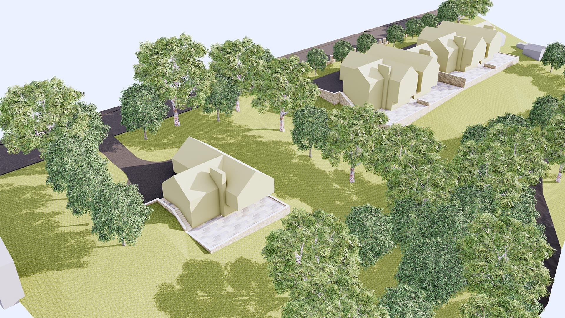
Planning Permission for Construction of 5 detached houses
Planning Application No. 24/0536/FUL
Topographical Report available on request
Greenfield Site, overlooks Boulsworth moorland
Views across the Wycollar Country Park and Trawden Forest
May split, selling the large, detached plot separately and the four detached house plots as one.
The land extends to approximately 1.91 acres (0.7745 hectares)
PRICE: Upon request
The site is Freehold
The purchase price is quoted exclusive of VAT, which may be payable at the prevailing rate
Description
The land is situated on Keighley Road (A6068) between two large private detached houses known as Eastfield and Croft House within approximately ¼ mile of the Emmott Arms and opposite Vernon Road. Colne town centre and its amenities are approximately 3 miles away, with access onto the M65 at J14 being just 3½ miles from the site.
There is a regular bus service along Keighley Road and the site is close to two well-respected and much sought-after primary schools.
The site has an approximate 130-metre frontage to Keighley Road. The land slopes down towards a brook known as Colne Water to the rear, and additional land adjacent to the brook may be available by separate negotiation. There are superb views across open countryside from this greenfield site.
TOWN PLANNING Planning Permission was obtained in December 2024 for the construction of 5 properties under Planning Application No. 24/0536/FUL – full details can be found on the Pendle Borough Council Planning Portal.
The landowners would consider a disposal of the large plot separately or, equally, the four detached house plots as one. They would also require the boundary with Eastfield to be at a greater distance from the property than shown on the current Planning Permission, and we anticipate that this would necessitate moving the properties in a westerly direction to maintain privacy for Eastfield and the properties to be developed.
SERVICES We are advised that all mains services are available along Keighley Road. Interested parties should satisfy themselves as to the availability of all services.
SITE AREA The land extends to approximately 1.91 acres
TENURE The site is Freehold
LEGAL COSTS: Each party is responsible for their own legal costs
Brochure
No brochure uploaded
No floorplans available
Ready to call this property your new home?
Don't miss the opportunity to make it yours, schedule a viewing today!
Used by Google Analytics to determine which links on a page are being clicked
30 seconds
_ga_
ID used to identify users
2 years
_gid
ID used to identify users for 24 hours after last activity
24 hours
_gat
Used to monitor number of Google Analytics server requests when using Google Tag Manager
1 minute
_gac_
Contains information related to marketing campaigns of the user. These are shared with Google AdWords / Google Ads when the Google Ads and Google Analytics accounts are linked together.
90 days
__utma
ID used to identify users and sessions
2 years after last activity
__utmt
Used to monitor number of Google Analytics server requests
10 minutes
__utmb
Used to distinguish new sessions and visits. This cookie is set when the GA.js javascript library is loaded and there is no existing __utmb cookie. The cookie is updated every time data is sent to the Google Analytics server.
30 minutes after last activity
__utmc
Used only with old Urchin versions of Google Analytics and not with GA.js. Was used to distinguish between new sessions and visits at the end of a session.
End of session (browser)
__utmz
Contains information about the traffic source or campaign that directed user to the website. The cookie is set when the GA.js javascript is loaded and updated when data is sent to the Google Anaytics server
6 months after last activity
__utmv
Contains custom information set by the web developer via the _setCustomVar method in Google Analytics. This cookie is updated every time new data is sent to the Google Analytics server.
2 years after last activity
__utmx
Used to determine whether a user is included in an A / B or Multivariate test.